


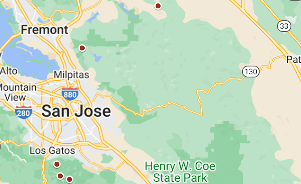
At the height of Sunday afternoon’s winds, more than 20 Bay Area weather stations recorded gusts over 80 mph, the National Weather Service said.
The map above shows the approximate locations of those stations. Click on each dot to see the wind speed and time.
The strongest gust was 102 mph, recorded at 4:40 p.m. at Pablo Point, near Nicasio in Marin County.
The top of the list, as of 8 p.m. Sunday:
Pablo Point, 102 mph, 4:40 p.m.
Road to Ranches, 99 mph, 5:40 p.m.
Loma Prieta, 98 mph, 2:35 p.m.
KNPT Towers, 97 mph, 3:30 p.m.
Pine Mountain Fire Road, 96 mph, 2:50 p.m.
Soda Springs Road, 96 mph, 4:40 p.m.
Gunsight Fire Road, 96 mph, 5:30 p.m.
Point Reyes, 89 mph, 2:20 p.m.
Lucas Valley, 89 mph, 4:10 p.m.
Los Gatos, 87 mph, 5:32 p.m.
Mount Umunhum, 85 mph, 3:20 p.m.
Mount Diablo, 83 mph, 4:30 p.m.
Mines Tower, 82 mph, 6:50 p.m.
Richardson East, 81 mph, 5:50 p.m.
Mount Alison (Mission Peak), 81 mph, 3:50 p.m.
Gusts above 80 mph were also recorded in Napa and Monterey counties, the weather service said.
Related Articles
Bay Area rain chart: Totals from 5 days of atmospheric river storms
Main swath of Bay Area storm fury exiting the region
AT&T Pebble Beach Pro-Am: Bad weather cancels final round, Wyndham Clark declared winner
AT&T Pebble Beach Pro-Am: A history of challenging weather
Emergency declared as Southern California storm is called potentially catastrophic and life-threatening


+ There are no comments
Add yours